


PDF files are used throughout the site. If you do not have adobe acrobat to open these files, you can down load it here.
© 2008 District III Planning and Development.
All Rights Reserved.
|
GIS NEEDS ASSESSMENTS
District III staff use a survey instrument to interview local department heads to help identify local GIS needs, data, software, hardware, and potential projects.
GIS ARCVIEW TRAINING & BASIC TECHNICAL SUPPORT (For Members Only):
District III will provide FREE basic ArcView training to help new users become familiar with the software. This service is NOT intended to replace professional training.
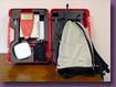
GPS DATA COLLECTION
District III utilizes a Leica GS50 GPS unit with sub-meter accuracy of approximately one (1) foot. District III has collected data on feedlots, water lines, water valves, manholes, fire hydrants, roads, landfills, rock piles, etc. Furthermore, District III is working with several rural water systems to accurately map transmission lines and construct digital database files to aide in operation and management decisions.
|
|
GEOCODING
This activity includes populating the DOT GPS road centerline data with address ranges. It will allow users to locate individual residences by typing in the E-911 address.
HOMELAND SECURITY
District III has been utilizing GPS and GIS to locate hazardous material sites, prepare Pre-Disaster Mitigation Plans and Local Emergency Operation Plans, develop Commodity Flow Studies, and support E-911 implementation.
Learn More |
|